About NavLink US
Marine Navigation App that turns your Apple Device in to a full function chart plotter. Features include: · Realtime GPS position plotted on Marine charts derived from NOAA data (Vector (ENC) & Raster (RNC)) · AIS overlay
Marine Navigation App that turns your Apple Device in to a full function chart plotter. Features include:
· Realtime GPS position plotted on Marine charts derived from NOAA data (Vector (ENC) & Raster (RNC))
· AIS overlay when connected to compatible wireless AIS system
· Waypoints & routes with full route editing and planning function
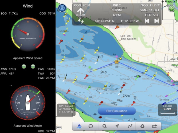
· Position, COG, SOG, VMG, bearing, distance & ETA displays
· Configurable chart layers
· HorizonView overlays navaid and targets onto iPad/Phone camera display
· Automatic free chart updates included for 1 year
· Weather buoy data
· A-B chart ruler for quick & easy bearing and distance measurement
· All NOAA US charts are included in the price
· Optional in-app purchase of CA charts
AIS Functionality
When connected to an AIS system via a wireless NMEA link, NavLink will provide a real time overlay of AIS targets and CPA and TCPA alarms. Internet AIS requires Boat Beacon app
HorizonView
Overlay chart & AIS objects on the iPhone or iPad camera image to create an augmented HorizonView display, that makes Nav-Aid & vessel identification simple and reliable
Plan & sail routes
Instant route and waypoint creation by tapping on screen. Route reverse function and route overview with inter-leg bearing and distance. Share your routes via dropbox and email with other users
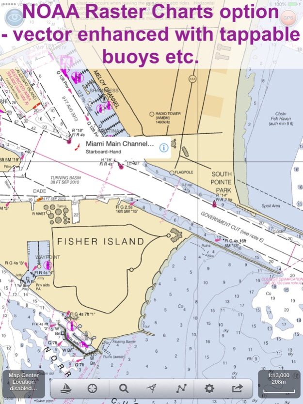
NavLink Charting
NavLink utilises the latest S57 based NOAA digital mapping & features automatic free updates for 1 year. With vector mapping, you can manage your layers of data to de-clutter the screen or maximise information. NavLink supports all key charting feature such as buoys, lights, bridges, depth contours, spot depths, depth contours, anchorage & military areas, weather buoys
Interfacing
NavLink is compatible with all Digital Yacht's wireless NMEA devices such as the iAIS, WLN10, WLN10HS, NavLink, iNavHub & PilotLink that stream wireless AIS data to your Apple device
If you have a WiFi-only iPad you will need an external Bluetooth GPS receiver to enable navigation. 3rd Party units are available such as the Garmin Glo.
Please note: Continued use of GPS running in the background can dramatically decrease battery life
Subscriptions
Your purchase includes 12 months free updates to the included chart set. At the end of the 12 month period continued access to ongoing chart updates is available via an in-app purchase. Charts for other regions may also be added to your product via optional in-app purchase.
Our in-app purchases are 1 year subscriptions, which automatically renew at the end of the subscription period unless auto-renew is turned off at least 24-hours before the end of the current period. Payment will be charged to your iTunes Account at confirmation of purchase, and will be charged for renewal within 24-hours prior to the end of the current period. Pricing for our 1 year US Charts update subscription is $9.99.
Subscriptions may be managed by the iTunes account holder and auto-renewal may be turned off by going to Account Settings after purchase.
No cancellation of the current subscription is allowed during active subscription period.
Privacy policy:- http://seanav.net/digitalyacht/privacy.php
Terms and conditions:- http://seanav.net/dyiostsandcs.php
Safety Notice
NavLink & the charts are intended to be used as an aid to navigation. Only official government charts and notice to mariners contain all of the current information needed for safe navigation. This product's features cannot be relied on to be complete or accurate and may vary locally. It is the Captain's or Boat Owner's responsibility to use official government charts, notice to mariners, caution, sound judgement and proper navigational skill when operating their vessel and using this or any other Digital Yacht product.
By purchasing this App, you are accepting the limitations of this app and the NOAA charts.
Third Party Licenses and Notices
NOTICE: US Marine Charts are derived from official NOAA Electronic Navigational Charts.
Sep 17, 2021
Version 5.3.5
Much much faster chart drawing on newer Apple devices ( iPhone 9 and later and iPad 6th gen and later)
Support for iOS Dark mode - better for night time vision and use.
NavLink iOS and its charts now works on the new MacBook M1.
Cardinal mark light patterns now displayed correctly in light details
NMEA instrument support for depth added and split screen iPad instruments view for wind and depth.
Improvements to seamless chart coverage
Improvements to In App Purchase experience
Fix for charts not drawing if no internet after fresh launch of the app
Previous Versions
Here you can find the changelog of NavLink US since it was posted on our website on 2016-11-06 18:23:02.
The latest version is 5.3.5 and it was updated on 2024-04-19 19:20:34. See below the changes in each version.
NavLink US version 5.3.5
Updated At: 2021-09-17
Changes: Sep 17, 2021 Version 5.3.5
Much much faster chart drawing on newer Apple devices ( iPhone 9 and later and iPad 6th gen and later)
Support for iOS Dark mode - better for night time vision and use.
NavLink iOS and its charts now works on the new MacBook M1.
Cardinal mark light patterns now displayed correctly in light details
NMEA instrument support for depth added and split screen iPad instruments view for wind and depth.
Improvements to seamless chart coverage
Improvements to In App Purchase experience
Fix for charts not drawing if no internet after fresh launch of the app
NavLink US version 4.3
Updated At: 2017-09-18
Changes: Sep 18, 2017 Version 4.3
iOS11 ready
NMEA Wind, Depth and Boat Speed instruments added.
Favourite Places (POIs):- Add markers for places you want to remember, add a photo and share them with friends too. Add fishing spots with a photo of the one that didn't get away, diving locations, cosy anchorages, hazards, reminders to call in on a VHF channel etc. Now you can also share and download favourite places and routes with the whole NavLink community via the NavLink web service :- http://seanav.net/pois . Check if others have added information in your area. Help others by sharing details on good anchorages, hazards, great diving spots or a proven route.
Air Draft: See if your boat will fit under a bridge or cable you are approaching in our unique augmented reality view.
Fix for enabling background location updates when in sailing mode.
Weather information now shows forecast in your local time zone.
Fix for NOAA raster charts.
NavLink US version 4.3
Updated At: 2017-09-18
Changes: Sep 18, 2017 Version 4.3
This app has been updated by Apple to use the latest Apple signing certificate.
iOS11 ready
NMEA Wind, Depth and Boat Speed instruments added.
Favourite Places (POIs):- Add markers for places you want to remember, add a photo and share them with friends too. Add fishing spots with a photo of the one that didn't get away, diving locations, cosy anchorages, hazards, reminders to call in on a VHF channel etc. Now you can also share and download favourite places and routes with the whole NavLink community via the NavLink web service :- http://seanav.net/pois . Check if others have added information in your area. Help others by sharing details on good anchorages, hazards, great diving spots or a proven route.
Air Draft: See if your boat will fit under a bridge or cable you are approaching in our unique augmented reality view.
Fix for enabling background location updates when in sailing mode.
Weather information now shows forecast in your local time zone.
Fix for NOAA raster charts.
NavLink US version 3.8
Updated At: 2014-02-21
NavLink US version 4.3
Updated At: 1970-01-01
Changes: 18 сент. 2017 г. Version 4.3
iOS11 ready
NMEA Wind, Depth and Boat Speed instruments added.
Favourite Places (POIs):- Add markers for places you want to remember, add a photo and share them with friends too. Add fishing spots with a photo of the one that didn't get away, diving locations, cosy anchorages, hazards, reminders to call in on a VHF channel etc. Now you can also share and download favourite places and routes with the whole NavLink community via the NavLink web service :- http://seanav.net/pois . Check if others have added information in your area. Help others by sharing details on good anchorages, hazards, great diving spots or a proven route.
Air Draft: See if your boat will fit under a bridge or cable you are approaching in our unique augmented reality view.
Fix for enabling background location updates when in sailing mode.
Weather information now shows forecast in your local time zone.
Fix for NOAA raster charts.
NavLink US version 4.3
Updated At: 1970-01-01
Changes: 2017年9月18日 Version 4.3
iOS11 ready
NMEA Wind, Depth and Boat Speed instruments added.
Favourite Places (POIs):- Add markers for places you want to remember, add a photo and share them with friends too. Add fishing spots with a photo of the one that didn't get away, diving locations, cosy anchorages, hazards, reminders to call in on a VHF channel etc. Now you can also share and download favourite places and routes with the whole NavLink community via the NavLink web service :- http://seanav.net/pois . Check if others have added information in your area. Help others by sharing details on good anchorages, hazards, great diving spots or a proven route.
Air Draft: See if your boat will fit under a bridge or cable you are approaching in our unique augmented reality view.
Fix for enabling background location updates when in sailing mode.
Weather information now shows forecast in your local time zone.
Fix for NOAA raster charts.
Disclaimer
Official App Store Link
We do not host NavLink US on our servers. We did not scan it for viruses, adware, spyware or other type of malware. This app is hosted by Apple and passed their terms and conditions to be listed there. We recommend caution when installing it.
The App Store link for NavLink US is provided to you by apps112.com without any warranties, representations or guarantees of any kind, so access it at your own risk.
If you have questions regarding this particular app contact the publisher directly. For questions about the functionalities of apps112.com contact us.